
Quick summaries of our programs are below.
For further details on a particular program please visit that page by selecting from the drop down under the programs tab or by clicking on the program title.
For further details on a particular program please visit that page by selecting from the drop down under the programs tab or by clicking on the program title.
Clean Water Fund

On November 4, 2008, Minnesota voters approved the Clean Water, Land & Legacy
Amendment to the constitution to: protect drinking water sources; - protect, enhance, and restore wetlands, prairies, forests, and fish, game, and wildlife habitat; - preserve arts and cultural heritage; - support parks and trails; - and protect, enhance, and restore lakes, rivers, streams, and groundwater. The Amendment increases the sales and use tax rate by three-eighths of one percent on taxable sales, starting July 1, 2009, continuing through 2034. Those dollars are dedicated to four funds: Outdoor Heritage Fund, Clean Water Fund, Parks and Trails Fund, and Arts and Cultural Heritage Fund. Click on the logo for more information.
Click here for Clean Water Land and Legacy stories.
Back to Top
GIS - Geographic Information System
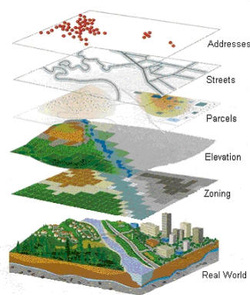
What is GIS?
A geographic information system (GIS) integrates hardware, software, and data for capturing, managing, analyzing, and displaying all forms of geographically referenced
information.
GIS is computer software that links geographic information (where things are) with descriptive information (what things are). Unlike a flat paper map, where what you see is what you get, GIS can present many layers of different information.
GIS allows us to view, understand, question, interpret, and visualize data in many ways that reveal relationships, patterns, and trends in the form of maps, globes, reports, and charts. A GIS helps you answer questions and solve problems by looking at your data in a way that is quickly understood and easily shared.
To learn more about GIS click here. To view Rock County GIS click here.
Feedlots
Minnesota's regulatory feedlot program is conducted through a cooperative arrangement between the Minnesota Pollution Control Agency (MPCA) and County Government. This cooperative program is known as "county delegation" or the "county feedlot program." A county feedlot program is established by the transfer of regulatory authority from the MPCA to the county. County feedlot programs have responsibility for implementing state feedlot regulations including registration, permitting, inspections, education and assistance and complaint follow up.
For more specific information please click the link below:
MPCA Feedlot Fact Sheets and Information
For more specific information please click the link below:
MPCA Feedlot Fact Sheets and Information
Subsurface Treatment Systems
Why replace a failing septic system?
It is unhealthy for humans, pets and wildlife to drink or come in contact with surface or groundwater contaminated with sewage. Inadequate treatment of sewage allows bacteria, viruses and other disease-causing pathogens to enter surface and groundwater. Hepatitis, dysentery and other disease may result from bacteria and viruses in drinking water. An inadequately vented septic system may release toxic gases into the home, disease-causing organisms may make lakes or streams unsafe for recreation and flies and mosquitoes that are attracted to and breed in wet areas where sewage reaches the surface may also spread disease. Inadequate treatment can also raise nitrate levels in groundwater which is a special risk to infants.
It is unhealthy for humans, pets and wildlife to drink or come in contact with surface or groundwater contaminated with sewage. Inadequate treatment of sewage allows bacteria, viruses and other disease-causing pathogens to enter surface and groundwater. Hepatitis, dysentery and other disease may result from bacteria and viruses in drinking water. An inadequately vented septic system may release toxic gases into the home, disease-causing organisms may make lakes or streams unsafe for recreation and flies and mosquitoes that are attracted to and breed in wet areas where sewage reaches the surface may also spread disease. Inadequate treatment can also raise nitrate levels in groundwater which is a special risk to infants.
Sale of Property
The state of MN and Rock County do not require a septic inspection upon the sale of property.
Should a lender require an inspection, we have two licensed septic inspectors on staff to assist you.
The state of MN and Rock County do not require a septic inspection upon the sale of property.
Should a lender require an inspection, we have two licensed septic inspectors on staff to assist you.
State Revolving Fund (Ag BMP)
The Rock SWCD along with the Minnesota Department of Agriculture work to provide loans for agricultural projects that reduce existing water quality problems caused by agricultural activities or failing septic systems and helps landowners comply with water related laws and rules. This loan program offers loans at 3% interest in which the landowner works with local banks. The first step to acquiring this loan is to contact the Land Management Office to have funds allocated at 3% interest. Contact the Land Management Office for further information at 283-8862.
The Rock SWCD along with the Minnesota Department of Agriculture work to provide loans for agricultural projects that reduce existing water quality problems caused by agricultural activities or failing septic systems and helps landowners comply with water related laws and rules. This loan program offers loans at 3% interest in which the landowner works with local banks. The first step to acquiring this loan is to contact the Land Management Office to have funds allocated at 3% interest. Contact the Land Management Office for further information at 283-8862.
Cost Share
State Cost Share
The State Cost Share Program is a viable source of funds that provide a financial incentive to landowners that wish to install conservation practices on their land including waterways, water and sediment control basins and cover crops. In addition to the State Cost Share Program, landowners have the opportunity to participate in various other cost-share or financial incentive programs. Individuals seeking financial or technical assistance will be informed of the Federal Environmental Quality Incentive Program (EQIP) and the State Revolving Loan Fund Program (also known as Ag BMP Loan Program). The SWCD and the NRCS (National Resource Conservation Service) provide technical assistance for the survey, design and installation of water quality practice.
State Cost Share - Well Sealing
State Cost Share funds are available to assist landowners with the cost of sealing unused wells. Funds are available for up to 50% of the cost or $300 whichever is less. Wells must be sealed by a licensed well sealer. Call our office to have your name put on the cost share list and bring us a copy of your paid bill to be reimbursed. It's that simple!
Native Grass Drill Program
The SWCD provides a grass drill for rent for producers to use in seeding various projects such as CRP acres, streambank stabilization, CREP acres, grass waterways and more. Click here for rental agreement and rates.
Please bring your seed tag (or a photo of it) with you and one of our staff will calibrate the drill for you.
Please bring your seed tag (or a photo of it) with you and one of our staff will calibrate the drill for you.
Ag BMP (Best Management Practices)
The Rock SWCD works with the Minnesota Department of Agriculture to provide 3% interest financing to farmers, rural landowners and agriculture supply businesses to encourage agricultural best management practices that prevent or reduce runoff from feedlots, farm fields and other pollution problems identified by the county in local water plans. This program provides loans for projects that reduce existing water quality problems caused by agricultural activities or failing septic systems and helps landowners comply with water related laws and rules. Visit the Ag BMP page for more information.
Trees
Rock SWCD offers a district Tree Program which provides landowners the opportunity to purchase, at bulk rate prices, bare root trees and shrubs that are zone 4 hardy. Continuous matting or square tree mats are also available to assist the landowner with weed control.
Tree orders are taken in November/December for delivery in April.
Trees may be planted by the landowners or by district staff. Trees planted by our staff are eligible for cost share which applies to the cost of the trees and the matting. For more information on cost, specific tree species availability and cost-share available through the Rock SWCD please visit the Trees page.
*Rock SWCD tree policies, species availability and prices are subject to change.
RIM (Reinvest in Minnesota)
BWSR’s Reinvest in Minnesota (RIM) Reserve program is a critical component of the state’s efforts to improve water quality by reducing soil erosion, and phosphorus and nitrogen loading, and improving wildlife habitat and flood attenuation on private lands. RIM Reserve is implemented in cooperation with county SWCDs. The RIM Reserve program compensates landowners for granting conservation easements and establishing native vegetation habitat on economically marginal, flood-prone, environmentally sensitive or highly erodible lands. The program protects the state’s water and soil resources by permanently restoring wetlands, adjacent native grassland wildlife habitat complexes and permanent riparian buffers.
Wetland Conservation Act (WCA)
The SWCD assists cities, townships, citizens and county departments in the administration of the Minnesota Wetland Conservation Act. SWCD staff provides technical assistance and acts as the "clearing house" for wetland and water related activities throughout Rock County.
Water
The Missouri River Watershed One-Watershed One Plan brings 6 counties, 6 Soil and Water Conservation Districts and 2 Watersheds together to develop a comprehensive plan that will address water management in the Missouri River Watershed. Prior to this evolutionary process each public entity developed their own strategic water plan. This new process will build off these existing local water management plans and priorities as well as align the local water planning process on major watershed boundaries. The Missouri River Watershed One Watershed-One Plan will be locally led and utilize state strategies towards prioritized, targeted and measurable implementation plans.
Recycling
Rock County is single sort recycling. Recyclables are collected by Ketterling Services, Inc. and taken to Millenium Recycling, Inc. in Sioux Falls. Please refer to the flyer below for what is and is not accepted. Please refer to the brochure on the recycling page for what is and is not accepted.
Household Hazardous Waste
Rock County residents may dispose of household hazardous waste products free of charge throughout the year by making an appointment with SWCD office. Appointments are taken for the first and third Thursday of each month. Products are brought to the Rock County Transfer Station and a staff member from our office will meet you there.
Ag Inspection
The first point of contact for any noxious weed complaints is your township official. If the issue does not get a resolved or a response from the landowner