
Our Mission: Protect our water and land resources by assisting Rock County landowners with understanding conservation rules and implementing best-management practices.
QUICK ACCESS LINKS
|
Earthwork and Tile Contractors
Tiling or Watercourse Clean-Out Requirements 1) Tiling Application 2) Watercourse cleanout |
|


|
Flooding threatens private drinking water wells. Public officials urge user to protect private wells from potential flooding contamination.
To read the full article, click below. www.health.state.mn.us/news/pressrel/2024/wells062124.html Click here for information on disinfecting your well. |
MDA REMINDS FARMERS OF PROPER BULK FERTILIZER STORAGE
Storage areas for dry and liquid fertilizer must be permitted.
3/20/2024
St. Paul, MN: Ahead of the planting season, the Minnesota Department of Agriculture (MDA) is reminding farmers of proper storage guidelines for bulk fertilizer.
Bulk liquid fertilizer can contaminate soil, surface water, and groundwater if a storage tank or pipe leaks. Dry fertilizer can also leach into the environment if it is placed on the ground and mixes with snow and rain.
To limit the risk of environmental impacts, liquid fertilizer tanks must be inside a containment system that will hold any spills. This is called secondary containment. Dry fertilizer must be stored on an impervious surface and in a roofed area that will protect its contents from the elements. There may be other requirements depending on the location of the stored dry fertilizer.
Farmers storing any amount of dry bulk fertilizer on the farm must get an MDA bulk storage permit. Farmers must also get an MDA permit if they’re storing more than 6,000 gallons of liquid fertilizer.
The storage permit application must include drawings for secondary containment. An application, along with a $100 fee, must be submitted prior to the start of construction or storage of any dry fertilizer or more than 6,000 gallons of liquid fertilizer. The permit application can be found on the MDA website via the following link:
Bulk Fertilizer Storage | Minnesota Department of Agriculture
Failing to comply with bulk fertilizer storage requirements may result in further enforcement actions by the MDA. Contamination from a release may also result in a costly environmental cleanup that could be averted when liquid bulk fertilizer tanks or dry fertilizer is in an MDA permitted containment. As a reminder, a release of fertilizer into the environment is an incident that must be immediately reported to the Minnesota Duty Officer at 1-800-422-0798.
For more information on bulk storage and permits, contact Matthew Parins at 651-201-6587 or [email protected].
Contact
Allen Sommerfeld, MDA Communications
651-201-6185
[email protected]

SOIL HEALTH DEMONSTRATION PLOT
The Rock County Soil Health Team partnering with the University Of MN Office Of Soil Health has established a field scale demonstration site to compare no-till farming with cover crops to conventional till farming without cover crops in a corn/soybean rotation with full width field equipment. The field is located in the SE ¼ of section 18 in Martin Township west of Hills.
Click here for a map of the location.
A Learning Block Method will be used for Comparison
Click here for a map of the location.
A Learning Block Method will be used for Comparison
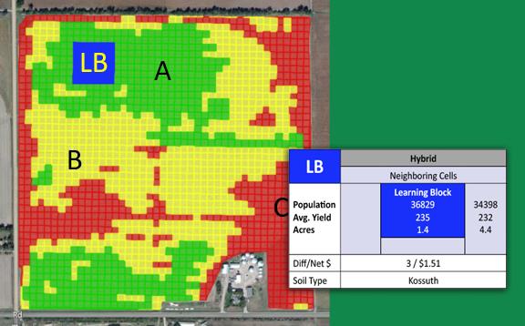
Using variable rate technology, data has been collected for historic yields, soils, fertility levels, cation-exchange capacities, etc., and generated variable-rate prescriptions for each grid of the field has been created.
3 acre learning block will be compared to the 4 acres surrounding the learning block and using algorithms to create a statistical analysis that develops a strong or weak correlation in treatment differences.
Comparing 3 treated acres to 4 non-treated acres transecting the entire field within a management zone is a great apples-to-apples comparison.
The project will run 3 years and calculate the economic results of the demonstration plots utilizing input expenses, crop yields and potential soil health benefits.
Plans are to hold field days at the site to present the findings.

2024 Calendar
7 pm - Monday, July 29, 2024
Rock County Planning and Zoning Commission Meeting
Rock County Law Enforcement Center
8 am - Monday, August 19, 2024
Rock SWCD Board Meeting
Rock County Land Management Office
7 pm - Monday, July 29, 2024
Rock County Planning and Zoning Commission Meeting
Rock County Law Enforcement Center
8 am - Monday, August 19, 2024
Rock SWCD Board Meeting
Rock County Land Management Office
Click the logo for more info
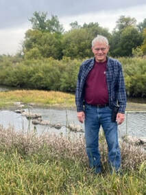
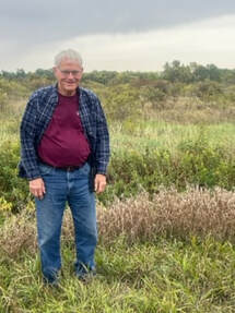
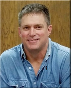
CONGRATULATIONS TO ART EHDE AND SCOTT EHDE
2023 ROCK COUNTY OUTSTANDING CONSERVATIONISTS
|
|
|
|
Art standing near one of the J-Hooks and the riparian buffer.
|
Scott Ehde
|
The Rock SWCD Board of Supervisors and staff awarded Art and the late Scott Ehde with the 2023 Outstanding Conservationist Award. Art and Scott started farming together in the mid 1990’s and have been nominated for this award for their leadership in sustainable crop management and their commitment to preserve wildlife habitat with multiple conservation practices.
They led the effort in promoting no-till crops in the area by providing custom no-till drilling and no-till planting on 1,700 acres per year to allow farmers to test these conservation methods. With the rising interest in cover crops, 80 acres of their own fields have been enrolled in a three year contract. Currently they utilize no-till to reduce sheet and rill erosion and have committed to installing two Water and Sediment Control Basins in the fall of 2023 to prevent gully erosion on their crop fields.
Working with their agronomist, they utilize best management practices such as grid sampling for nutrient management as well as pest resistant crop varieties and scouting of their crop field to apply pesticides only when needed.
Art and Scott established multiple conservation practices to enhance wildlife habitat. They planted a 10.9 acre Riparian Forest Buffer easement consisting of 5,900 trees along the Rock River and Mound Creek and have enrolled 18.5 acres in SAFE CRP to provide great habitat for deer, pheasants and turkeys along the Rock River. They stabilized two sections of stream bank on the Rock River using engineered J-Hook structures that are also designed to provide habitat for fish. They worked with US Fish and Wildlife to restore several oxbows along the Rock River that provide habitat for the Federally endangered Topeka Shiner as well as other waterfowl. It was through an immense love of hunting and fishing, that Art shared with his son Scott and a grandsons Jonathan and Carson, that he and Scott were inspired to establish these conservation practices.
Art has served his community through their Church Council and Caring Ministries. He was also a member
and helped organize and lead Compassionate Friends fo 6 years. In the course of that time, through the loss of his own daughter Pam, he helped many people in the process of learning to live beside their grief. He saw so many coming in such immense pain, returning because they found a place where others truly understand, and eventually he saw many smile again.
What Art and Scott have done, not only for themselves, provided a means for others to explore different conservation methods in crop management. This service demonstrates their commitment to enhancing and protecting the land. Their efforts to create wildlife habitat including endangered species demonstrates their dedication to conservation efforts to protect and preserve animal existence.
Art and Scott have been prime examples of what it means to love the land and be good stewards of that land through their farming practices and wildlife conservation efforts.
MN CREP
WHAT IS MN CREP (Conservation Reserve Enhancement Program)?
MN CREP is a voluntary, federal-state funded natural resource conservation program that uses a science based approach to target environmentally sensitive land in 54 Counties in southern and western Minnesota. This is accomplished through permanent protection by establishing conservation practices via payments to farmers and agricultural land owners.
CLICK HERE FOR FURTHER INFORMATION ON:
How it works.
MN CREP Objectives
How the will be restored and protected.
Why enroll now?
Enrollment - Contact the Rock County Land Management Office
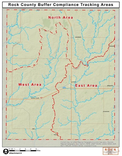
MINNESOTA BUFFER LAW
The Minnesota Board of Water and Soil Resources oversees implementation of the Buffer Law, which requires farmers to have vegetated buffers along cropland that borders ditches, streams, rivers and lakes. In accordance with the MN Board of Soil and Water Resources, Rock SWCD has developed a plan for Buffer Compliance Tracking. Click here for further information.
ROCK SWCD MONITORING PLAN FOR BUFFER COMPLIANCE TRACKING
|
|
Large Energy Wind Conversion Systems
Permitting Process
Minnesota Rules 7854
*Timeline from application acceptance to permit decision is 180 days.
Click here for a flowchart of the process.
Permitting Process
Minnesota Rules 7854
*Timeline from application acceptance to permit decision is 180 days.
Click here for a flowchart of the process.
MN Department of Commerce
Environmental Review of Energy Projects
The Minnesota Department of Commerce Energy Environmental Review and Analysis (EERA) unit conducts environmental review of proposed energy projects including power plants, transmission lines, wind farms, and pipelines. EERA conducts environmental review on behalf of the Minnesota Public Utilities Commission (Commission), and EERA’s environmental review informs the permit decisions made by the Commission.
Click here for the Department of Commerce and further information.
Guides to Prairie Restoration in Minnesota
Restoring a prairie just got easier.
Many landowners and managers have land that they would like to see covered with native flowers and grasses. But, creating a prairie is hard and often unpredictable work. The techniques and types of seeds planted will vary depending on the current state of the land, how moist or dry the site is, and type of prairie you would like to establish.
To deal with these issues, The Nature Conservancy and the University of Minnesota have developed 20 different restoration guides, each specific to one of five different types of starting conditions, two different moisture levels, and two different intended uses for restored prairie.
Each guide includes recommended techniques, timing and plant species, as well as estimated costs for completing a successful prairie restoration. The guides can be downloaded for free at: