
GEOGRAPHIC INFORMATION SYSTEM - GIS
What is GIS?
A geographic information system (GIS) integrates hardware, software, and data for capturing, managing, analyzing, and displaying all forms of geographically referenced information.
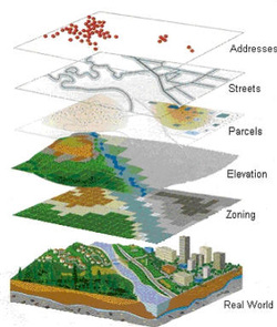
GIS is computer software that links geographic information (where things are) with descriptive information (what things are). Unlike a flat paper map, where what you see is what you get, GIS can present many layers of different information.
GIS allows us to view, understand, question, interpret, and visualize data in many ways that reveal relationships, patterns, and trends in the form of maps, globes, reports, and charts. A GIS helps you answer questions and solve problems by looking at your data in
a way that is quickly understood and easily shared.
A geographic information system (GIS) integrates hardware, software, and data for capturing, managing, analyzing, and displaying all forms of geographically referenced information.
GIS is computer software that links geographic information (where things are) with descriptive information (what things are). Unlike a flat paper map, where what you see is what you get, GIS can present many layers of different information.
GIS allows us to view, understand, question, interpret, and visualize data in many ways that reveal relationships, patterns, and trends in the form of maps, globes, reports, and charts. A GIS helps you answer questions and solve problems by looking at your data in
a way that is quickly understood and easily shared.